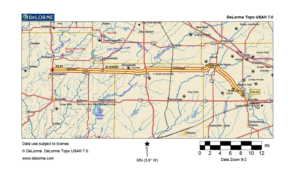
Indiana State Road 236
Not long ago, a fellow roadie from the Indy area (code name “mobilene”) had a post on his blog about an end to end trip he took on Indiana State Road 42. I’ve admired his writings of his road logs and vowed to start documenting some routes in our home state as well. I figure together we should wrap up the entire state by the time we’re in our mid-late 110’s.
My first…and hopefully not last…entry is based on a route that goes all the way back to my very beginnings: State Road 236. It stretches from just north of Danville and makes a 41 mile trek through west central Indiana farmlands to its end at US 41, about 6 miles north of Rockville.
Most of you aren’t aware that we started “geocaching” last year and got hooked on it pretty good. For those of you who’ve never heard of it, in the simplest terms, geocaching can best be described as using multi million dollar government satellites to find Tupperware filled with toys hidden in the woods. To do it, you need a GPS and an account at http://geocaching.com. You get your tupperware (or other appropriate container), find a hiding place for it, mark the coordinates on your GPS, then enter it all on the geocaching web site. Then, other folks with GPS and a sense of adventure will take the coordinates and try to find your cache. When they do, they sign the log that’s in it, and put the cache back in its hiding place for the next geocacher to find. Simple enough, eh? I have two caches of my own out there. One near my office and the other in a cemetery in North Salem, Indiana where some of my mom’s side of the family are resting forever.

I got word from someone who found my cache a few weeks back that it was in bad shape. An animal of some sort with sharp teeth had chewed on it and water had got inside and ruined the log. So, I disabled the cache on the web site and today part of my SR-236 trip was to replace the old container with a new one.

After I accomplished that mission, I was pulling over in “downtown” North Salem to snap a couple of shots when my oldest brother & his wife passed going the other way. He moved out there about 20 years ago. After a brief chat, we were on our separate ways. Not much going on in North Salem on this Sunday. The only thing open was the gas station. Everyone else was home for the day…most of its 591 population.

State Road 236 isn’t going to excite most two-lane roadies, but still, it’s got its charm. The largest town on the road is Roachdale with a population of 975. What’s unique about SR-236 is that there is not one stop light on its 41 mile length. And, the only stop between the two endpoints is at US 231, where SR-236 piggybacks it for a short distance.

Near Guion, which is little more than a handful of houses, 236 comes in contact with The Ben Hur Route. This was an auto trail within Indiana that stretched from Terre Haute up to Fort Wayne, beginning around 1918. The Ben Hur overlaps 236 at Guion for a mile or so. In this photo, the BH continues straight on the snow-covered gravel road, as 236 hooks to the right.

Marshall is the last “big” town (population 360) SR-236 cuts through on its trek west. Marshall resides in Parke County, which is famous not only for it’s 31 covered bridges , but it’s also rich in Amish residents. I happened to encounter one while exploring what there was to explore in Marshall.

Shortly after Marshall, SR-236 greets its western terminus at US 41, 6 miles north of Rockville, the Parke County seat. 236 isn’t a major state road through Indiana by any means, but the route…even prior to it being given a number…has a lengthy history dating back to the 1800’s, and is still important to the daily lives of those who live on & near it.

The rest of the slide show can be found here on Flickr.